


Retour Reimberg -> Hobscheid

fabrice.delfosse
User
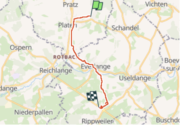

Length
7.2 km

Max alt
338 m

Uphill gradient
88 m
Km-Effort
8.6 km

Min alt
245 m

Downhill gradient
147 m
Boucle
No
Creation date :
2024-05-19 13:59:24.138
Updated on :
2024-05-21 05:25:38.954
1h44
Difficulty : Medium

FREE GPS app for hiking
 SityTrail
IGN / Geographical institutes
SityTrail Plus
The world is yours!
About
Trail Walking of 7.2 km to be discovered at Unknown, Canton Redange, Préizerdaul. This trail is proposed by fabrice.delfosse.
Positioning
Country:
Luxembourg
Region :
Unknown
Department/Province :
Canton Redange
Municipality :
Préizerdaul
Location:
Unknown
Start:(Dec)
Start:(UTM)
712374 ; 5520233 (31U) N.
Comments