


les crêtes d'Alaric

Mascart
User
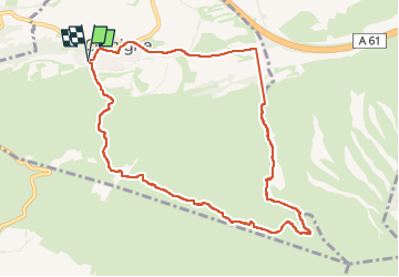

Length
10.3 km

Max alt
447 m

Uphill gradient
354 m
Km-Effort
15 km

Min alt
108 m

Downhill gradient
354 m
Boucle
Yes
Creation date :
2024-05-21 11:31:04.93
Updated on :
2024-05-21 16:34:51.394
3h30
Difficulty : Medium

FREE GPS app for hiking
 SityTrail
IGN / Geographical institutes
SityTrail Plus
The world is yours!
About
Trail Walking of 10.3 km to be discovered at Occitania, Aude, Comigne. This trail is proposed by Mascart.
Description
départ de Comigne
Positioning
Country:
France
Region :
Occitania
Department/Province :
Aude
Municipality :
Comigne
Location:
Unknown
Start:(Dec)
Start:(UTM)
465588 ; 4779636 (31T) N.
Comments