


haut Langdoc etap5

taguette
User
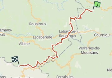

Length
31 km

Max alt
994 m

Uphill gradient
929 m
Km-Effort
44 km

Min alt
392 m

Downhill gradient
873 m
Boucle
No
Creation date :
2024-05-21 06:14:10.584
Updated on :
2024-05-21 16:47:38.596
10h31
Difficulty : Very difficult

FREE GPS app for hiking
 SityTrail
IGN / Geographical institutes
SityTrail Plus
The world is yours!
About
Trail Walking of 31 km to be discovered at Occitania, Hérault, Courniou. This trail is proposed by taguette.
Positioning
Country:
France
Region :
Occitania
Department/Province :
Hérault
Municipality :
Courniou
Location:
Unknown
Start:(Dec)
Start:(UTM)
475109 ; 4817648 (31T) N.
Comments