


les trois fours/Hohneck

geoffrayLayeux
User
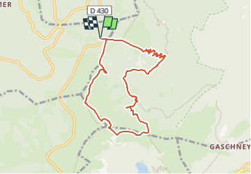

Length
8.1 km

Max alt
1352 m

Uphill gradient
446 m
Km-Effort
14 km

Min alt
964 m

Downhill gradient
446 m
Boucle
Yes
Creation date :
2024-05-21 20:18:16.013
Updated on :
2024-05-21 20:18:18.462
3h11
Difficulty : Difficult

FREE GPS app for hiking
 SityTrail
IGN / Geographical institutes
SityTrail Plus
The world is yours!
About
Trail Walking of 8.1 km to be discovered at Grand Est, Vosges, Xonrupt-Longemer. This trail is proposed by geoffrayLayeux.
Positioning
Country:
France
Region :
Grand Est
Department/Province :
Vosges
Municipality :
Xonrupt-Longemer
Location:
Unknown
Start:(Dec)
Start:(UTM)
352053 ; 5323993 (32U) N.
Comments