


Tour Ile de BATZ

bianchireg
User

Length
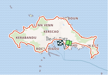
12.4 km

Max alt
26 m

Uphill gradient
110 m
Km-Effort
13.9 km

Min alt
0 m

Downhill gradient
110 m
Boucle
Yes
Creation date :
2024-05-23 05:42:39.673
Updated on :
2024-05-23 05:42:48.666
3h09
Difficulty : Medium

FREE GPS app for hiking
 SityTrail
IGN / Geographical institutes
SityTrail Plus
The world is yours!
About
Trail Walking of 12.4 km to be discovered at Brittany, Finistère, Île-de-Batz. This trail is proposed by bianchireg.
Positioning
Country:
France
Region :
Brittany
Department/Province :
Finistère
Municipality :
Île-de-Batz
Location:
Unknown
Start:(Dec)
Start:(UTM)
425851 ; 5399104 (30U) N.
Comments
excellent