


la chapelotte Pierre percé

molusk
User
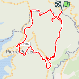

Length
13.6 km

Max alt
538 m

Uphill gradient
422 m
Km-Effort
19.2 km

Min alt
321 m

Downhill gradient
423 m
Boucle
Yes
Creation date :
2015-04-11 00:00:00.0
Updated on :
2015-04-11 00:00:00.0
3h50
Difficulty : Medium

FREE GPS app for hiking
 SityTrail
IGN / Geographical institutes
SityTrail Plus
The world is yours!
About
Trail Other activity of 13.6 km to be discovered at Grand Est, Meurthe-et-Moselle, Angomont. This trail is proposed by molusk.
Positioning
Country:
France
Region :
Grand Est
Department/Province :
Meurthe-et-Moselle
Municipality :
Angomont
Location:
Unknown
Start:(Dec)
Start:(UTM)
348962 ; 5372064 (32U) N.
Comments