


Château sur Epte et allée couverte

Fky78
User
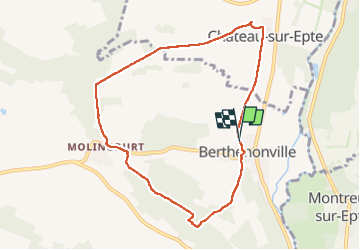

Length
7.8 km

Max alt
136 m

Uphill gradient
134 m
Km-Effort
9.6 km

Min alt
45 m

Downhill gradient
140 m
Boucle
Yes
Creation date :
2024-05-23 13:29:37.733
Updated on :
2024-05-23 16:05:28.971
2h15
Difficulty : Medium

FREE GPS app for hiking
 SityTrail
IGN / Geographical institutes
SityTrail Plus
The world is yours!
About
Trail Walking of 7.8 km to be discovered at Normandy, Eure, Vexin-sur-Epte. This trail is proposed by Fky78.
Positioning
Country:
France
Region :
Normandy
Department/Province :
Eure
Municipality :
Vexin-sur-Epte
Location:
Unknown
Start:(Dec)
Start:(UTM)
402261 ; 5448838 (31U) N.
Comments