


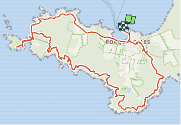
Ile de Porquerolles côté ouest 24-05-2024

Christiancordin
User


5h02
Difficulty : Medium

FREE GPS app for hiking
 SityTrail
IGN / Geographical institutes
SityTrail Plus
The world is yours!
About
Trail On foot of 17.3 km to be discovered at Provence-Alpes-Côte d'Azur, Var, Hyères. This trail is proposed by Christiancordin.
Description
Départ capitainerie, château fort, moulin du bonheur, grand cale, pointe de l'indienne, phare de Porquerolles, rocher de la croix, gorges du loup, vallon de Fortuné, calanque du Bregançonnet, port Fay, fort du Langoustier, Porquerolles.
Photos


Positioning
Comments