


2024-05-30 Andresy Matin

Rando MLC
User
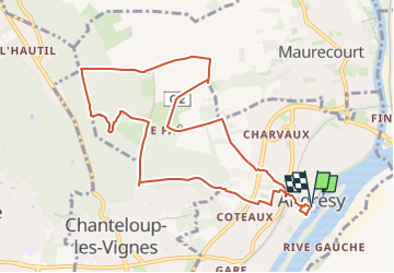

Length
9.7 km

Max alt
174 m

Uphill gradient
256 m
Km-Effort
13.1 km

Min alt
22 m

Downhill gradient
254 m
Boucle
Yes
Creation date :
2024-05-25 08:06:45.081
Updated on :
2024-05-26 08:08:45.928
2h58
Difficulty : Medium

FREE GPS app for hiking
 SityTrail
IGN / Geographical institutes
SityTrail Plus
The world is yours!
About
Trail Walking of 9.7 km to be discovered at Ile-de-France, Yvelines, Andrésy. This trail is proposed by Rando MLC.
Positioning
Country:
France
Region :
Ile-de-France
Department/Province :
Yvelines
Municipality :
Andrésy
Location:
Unknown
Start:(Dec)
Start:(UTM)
431290 ; 5425820 (31U) N.
Comments