


bonolet

tobia
User
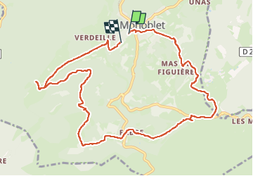

Length
12.3 km

Max alt
392 m

Uphill gradient
264 m
Km-Effort
15.9 km

Min alt
200 m

Downhill gradient
277 m
Boucle
No
Creation date :
2024-05-25 07:22:40.039
Updated on :
2024-05-25 11:14:06.908
3h50
Difficulty : Difficult

FREE GPS app for hiking
 SityTrail
IGN / Geographical institutes
SityTrail Plus
The world is yours!
About
Trail Walking of 12.3 km to be discovered at Occitania, Gard, Monoblet. This trail is proposed by tobia.
Positioning
Country:
France
Region :
Occitania
Department/Province :
Gard
Municipality :
Monoblet
Location:
Unknown
Start:(Dec)
Start:(UTM)
570967 ; 4872227 (31T) N.
Comments