


L'Aventure du rail

daniellebou
User
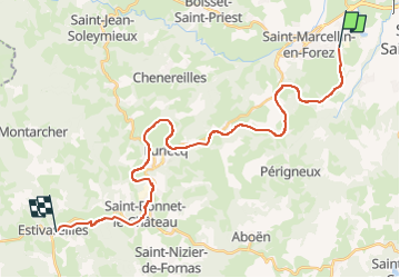

Length
28 km

Max alt
957 m

Uphill gradient
693 m
Km-Effort
36 km

Min alt
413 m

Downhill gradient
218 m
Boucle
No
Creation date :
2024-05-25 18:56:48.891
Updated on :
2024-05-25 19:01:27.278
3h30
Difficulty : Very easy

FREE GPS app for hiking
 SityTrail
IGN / Geographical institutes
SityTrail Plus
The world is yours!
About
Trail Cycle of 28 km to be discovered at Auvergne-Rhône-Alpes, Loire, Saint-Marcellin-en-Forez. This trail is proposed by daniellebou.
Points of interest


Positioning
Country:
France
Region :
Auvergne-Rhône-Alpes
Department/Province :
Loire
Municipality :
Saint-Marcellin-en-Forez
Location:
Unknown
Start:(Dec)
Start:(UTM)
592634 ; 5038779 (31T) N.
Comments