


Wachet Châtillon chantemelle saint leger

iznogud
User
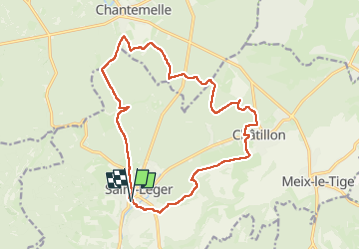

Length
16.3 km

Max alt
366 m

Uphill gradient
292 m
Km-Effort
20 km

Min alt
256 m

Downhill gradient
291 m
Boucle
Yes
Creation date :
2024-05-26 08:53:32.0
Updated on :
2024-05-26 11:40:45.1

FREE GPS app for hiking
 SityTrail
IGN / Geographical institutes
SityTrail Plus
The world is yours!
About
Trail of 16.3 km to be discovered at Wallonia, Luxembourg, Saint-Léger. This trail is proposed by iznogud.
Positioning
Country:
Belgium
Region :
Wallonia
Department/Province :
Luxembourg
Municipality :
Saint-Léger
Location:
Saint-Léger
Start:(Dec)
Start:(UTM)
691759 ; 5498744 (31U) N.
Comments