


Jour 2 Montbonnet à Moniqtrol d'Allier

BOUMA
User
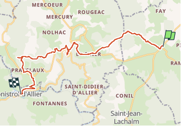

Length
17.1 km

Max alt
1214 m

Uphill gradient
371 m
Km-Effort
24 km

Min alt
597 m

Downhill gradient
865 m
Boucle
No
Creation date :
2024-05-25 06:34:17.069
Updated on :
2024-05-26 12:57:24.687
7h07
Difficulty : Difficult

FREE GPS app for hiking
 SityTrail
IGN / Geographical institutes
SityTrail Plus
The world is yours!
About
Trail Nordic walking of 17.1 km to be discovered at Auvergne-Rhône-Alpes, Haute-Loire, Bains. This trail is proposed by BOUMA.
Positioning
Country:
France
Region :
Auvergne-Rhône-Alpes
Department/Province :
Haute-Loire
Municipality :
Bains
Location:
Unknown
Start:(Dec)
Start:(UTM)
558627 ; 4982242 (31T) N.
Comments