


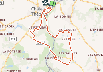
Tour de la Maine et des Vignes

webmammuth
User

Length
10.2 km

Max alt
55 m

Uphill gradient
127 m
Km-Effort
11.9 km

Min alt
6 m

Downhill gradient
127 m
Boucle
Yes
Creation date :
2024-05-26 13:42:08.82
Updated on :
2024-05-26 16:30:28.121
2h34
Difficulty : Very easy

FREE GPS app for hiking
 SityTrail
IGN / Geographical institutes
SityTrail Plus
The world is yours!
About
Trail Walking of 10.2 km to be discovered at Pays de la Loire, Loire-Atlantique, Château-Thébaud. This trail is proposed by webmammuth.
Positioning
Country:
France
Region :
Pays de la Loire
Department/Province :
Loire-Atlantique
Municipality :
Château-Thébaud
Location:
Unknown
Start:(Dec)
Start:(UTM)
620138 ; 5220282 (30T) N.
Comments