


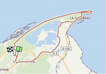
La Mollière - Pointe du Hourdel - AR

cordierlavenant
User

Length
9.6 km

Max alt
11 m

Uphill gradient
31 m
Km-Effort
10.1 km

Min alt
0 m

Downhill gradient
31 m
Boucle
Yes
Creation date :
2024-05-26 15:33:02.881
Updated on :
2024-05-26 17:22:31.651
1h49
Difficulty : Easy

FREE GPS app for hiking
 SityTrail
IGN / Geographical institutes
SityTrail Plus
The world is yours!
About
Trail Walking of 9.6 km to be discovered at Hauts-de-France, Somme, Cayeux-sur-Mer. This trail is proposed by cordierlavenant.
Positioning
Country:
France
Region :
Hauts-de-France
Department/Province :
Somme
Municipality :
Cayeux-sur-Mer
Location:
Unknown
Start:(Dec)
Start:(UTM)
394856 ; 5561991 (31U) N.
Comments