


Navacelle 2

Vox463
User
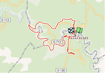

Length
13.3 km

Max alt
667 m

Uphill gradient
661 m
Km-Effort
22 km

Min alt
330 m

Downhill gradient
667 m
Boucle
Yes
Creation date :
2024-05-26 18:41:19.365
Updated on :
2024-05-26 18:41:44.277
5h02
Difficulty : Very difficult

FREE GPS app for hiking
 SityTrail
IGN / Geographical institutes
SityTrail Plus
The world is yours!
About
Trail Walking of 13.3 km to be discovered at Occitania, Hérault, Saint-Maurice-Navacelles. This trail is proposed by Vox463.
Positioning
Country:
France
Region :
Occitania
Department/Province :
Hérault
Municipality :
Saint-Maurice-Navacelles
Location:
Unknown
Start:(Dec)
Start:(UTM)
540973 ; 4860306 (31T) N.
Comments