


boucle en huit à Alembon de 14.6km et 250m déniv

eaea7charles
User
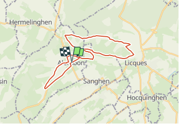

Length
14.6 km

Max alt
178 m

Uphill gradient
254 m
Km-Effort
18 km

Min alt
79 m

Downhill gradient
254 m
Boucle
Yes
Creation date :
2024-05-27 07:09:00.21
Updated on :
2024-05-27 07:10:28.574
4h04
Difficulty : Difficult

FREE GPS app for hiking
 SityTrail
IGN / Geographical institutes
SityTrail Plus
The world is yours!
About
Trail Walking of 14.6 km to be discovered at Hauts-de-France, Pas-de-Calais, Alembon. This trail is proposed by eaea7charles.
Description
Sentier du ventu
Positioning
Country:
France
Region :
Hauts-de-France
Department/Province :
Pas-de-Calais
Municipality :
Alembon
Location:
Unknown
Start:(Dec)
Start:(UTM)
421598 ; 5626469 (31U) N.
Comments