


Laguiole-CascadeDesOules-Eglise

raymondfn
User
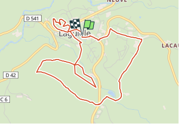

Length
6.5 km

Max alt
1045 m

Uphill gradient
147 m
Km-Effort
8.5 km

Min alt
981 m

Downhill gradient
146 m
Boucle
Yes
Creation date :
2024-05-27 08:59:27.382
Updated on :
2024-05-27 09:21:25.557
1h55
Difficulty : Medium

FREE GPS app for hiking
 SityTrail
IGN / Geographical institutes
SityTrail Plus
The world is yours!
About
Trail Walking of 6.5 km to be discovered at Occitania, Aveyron, Laguiole. This trail is proposed by raymondfn.
Positioning
Country:
France
Region :
Occitania
Department/Province :
Aveyron
Municipality :
Laguiole
Location:
Unknown
Start:(Dec)
Start:(UTM)
487972 ; 4947807 (31T) N.
Comments