


vol budapest

jmheydorff
User
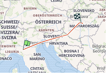

Length
796 km

Max alt
1087 m

Uphill gradient
16504 m
Km-Effort
1016 km

Min alt
-8 m

Downhill gradient
16521 m
Boucle
No
Creation date :
2024-05-27 07:49:31.961
Updated on :
2024-05-27 10:03:09.884
1h18
Difficulty : Very easy

FREE GPS app for hiking
 SityTrail
IGN / Geographical institutes
SityTrail Plus
The world is yours!
About
Trail Plane of 796 km to be discovered at Emilia-Romagna, Parma, Montechiarugolo. This trail is proposed by jmheydorff.
Positioning
Country:
Italy
Region :
Emilia-Romagna
Department/Province :
Parma
Municipality :
Montechiarugolo
Location:
Unknown
Start:(Dec)
Start:(UTM)
610358 ; 4948856 (32T) N.
Comments