


cavaillon 18/20 27/5/2024

vinc2788
User
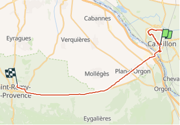

Length
27 km

Max alt
185 m

Uphill gradient
229 m
Km-Effort
30 km

Min alt
47 m

Downhill gradient
256 m
Boucle
No
Creation date :
2024-05-27 09:11:43.799
Updated on :
2024-05-27 12:37:16.943
3h25
Difficulty : Easy

FREE GPS app for hiking
 SityTrail
IGN / Geographical institutes
SityTrail Plus
The world is yours!
About
Trail Walking of 27 km to be discovered at Provence-Alpes-Côte d'Azur, Vaucluse, Cavaillon. This trail is proposed by vinc2788.
Positioning
Country:
France
Region :
Provence-Alpes-Côte d'Azur
Department/Province :
Vaucluse
Municipality :
Cavaillon
Location:
Unknown
Start:(Dec)
Start:(UTM)
663637 ; 4855451 (31T) N.
Comments