


J2 margeride arzenc-bouviers 25k

ophness
User
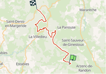

Length
24 km

Max alt
1489 m

Uphill gradient
503 m
Km-Effort
30 km

Min alt
1275 m

Downhill gradient
354 m
Boucle
No
Creation date :
2024-05-27 17:45:46.0
Updated on :
2024-05-27 17:45:47.368

FREE GPS app for hiking
 SityTrail
IGN / Geographical institutes
SityTrail Plus
The world is yours!
About
Trail of 24 km to be discovered at Occitania, Lozère, Arzenc-de-Randon. This trail is proposed by ophness.
Positioning
Country:
France
Region :
Occitania
Department/Province :
Lozère
Municipality :
Arzenc-de-Randon
Location:
Unknown
Start:(Dec)
Start:(UTM)
547225 ; 4946247 (31T) N.
Comments