


boitage forcalquier

dumotier
User
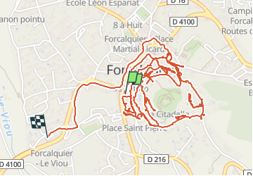

Length
5.9 km

Max alt
583 m

Uphill gradient
90 m
Km-Effort
7.2 km

Min alt
522 m

Downhill gradient
120 m
Boucle
No
Creation date :
2024-05-28 06:48:36.948
Updated on :
2024-05-28 09:42:15.001
1h59
Difficulty : Medium

FREE GPS app for hiking
 SityTrail
IGN / Geographical institutes
SityTrail Plus
The world is yours!
About
Trail Walking of 5.9 km to be discovered at Provence-Alpes-Côte d'Azur, Alpes-de-Haute-Provence, Forcalquier. This trail is proposed by dumotier.
Positioning
Country:
France
Region :
Provence-Alpes-Côte d'Azur
Department/Province :
Alpes-de-Haute-Provence
Municipality :
Forcalquier
Location:
Unknown
Start:(Dec)
Start:(UTM)
723008 ; 4870909 (31T) N.
Comments