


Carcassonne Quillan etap2

taguette
User
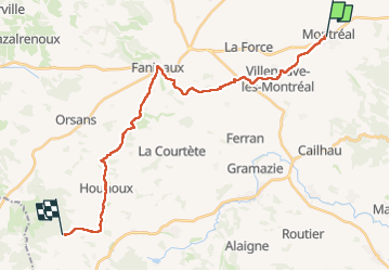

Length
26 km

Max alt
454 m

Uphill gradient
595 m
Km-Effort
33 km

Min alt
174 m

Downhill gradient
452 m
Boucle
No
Creation date :
2024-05-28 06:00:11.388
Updated on :
2024-05-28 17:06:02.575
9h52
Difficulty : Very difficult

FREE GPS app for hiking
 SityTrail
IGN / Geographical institutes
SityTrail Plus
The world is yours!
About
Trail Walking of 26 km to be discovered at Occitania, Aude, Montréal. This trail is proposed by taguette.
Positioning
Country:
France
Region :
Occitania
Department/Province :
Aude
Municipality :
Montréal
Location:
Unknown
Start:(Dec)
Start:(UTM)
430239 ; 4783339 (31T) N.
Comments