


J3G2

LouisROGER
User GUIDE
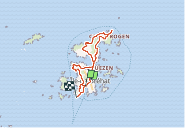

Length
12.6 km

Max alt
28 m

Uphill gradient
154 m
Km-Effort
14.7 km

Min alt
-1 m

Downhill gradient
165 m
Boucle
No
Creation date :
2024-05-27 08:50:06.813
Updated on :
2024-05-28 19:05:37.227
6h06
Difficulty : Difficult

FREE GPS app for hiking
 SityTrail
IGN / Geographical institutes
SityTrail Plus
The world is yours!
About
Trail Walking of 12.6 km to be discovered at Brittany, Côtes-d'Armor, Île-de-Bréhat. This trail is proposed by LouisROGER.
Positioning
Country:
France
Region :
Brittany
Department/Province :
Côtes-d'Armor
Municipality :
Île-de-Bréhat
Location:
Unknown
Start:(Dec)
Start:(UTM)
499733 ; 5409749 (30U) N.
Comments