


Trace Tregastel G1 Guy

mitch1952
User
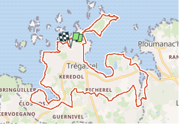

Length
17.2 km

Max alt
37 m

Uphill gradient
166 m
Km-Effort
19.4 km

Min alt
-1 m

Downhill gradient
166 m
Boucle
Yes
Creation date :
2024-05-29 07:23:02.0
Updated on :
2024-05-29 14:09:17.869

FREE GPS app for hiking
 SityTrail
IGN / Geographical institutes
SityTrail Plus
The world is yours!
About
Trail of 17.2 km to be discovered at Brittany, Côtes-d'Armor, Trégastel. This trail is proposed by mitch1952.
Positioning
Country:
France
Region :
Brittany
Department/Province :
Côtes-d'Armor
Municipality :
Trégastel
Location:
Unknown
Start:(Dec)
Start:(UTM)
462196 ; 5408773 (30U) N.
Comments