


essai parcours

psesjs
User
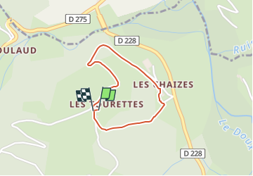

Length
1.4 km

Max alt
565 m

Uphill gradient
70 m
Km-Effort
2.3 km

Min alt
488 m

Downhill gradient
68 m
Boucle
Yes
Creation date :
2024-05-29 16:19:24.601
Updated on :
2024-05-29 16:19:23.639
31m
Difficulty : Easy

FREE GPS app for hiking
 SityTrail
IGN / Geographical institutes
SityTrail Plus
The world is yours!
About
Trail Walking of 1.4 km to be discovered at Auvergne-Rhône-Alpes, Ardèche, Désaignes. This trail is proposed by psesjs.
Positioning
Country:
France
Region :
Auvergne-Rhône-Alpes
Department/Province :
Ardèche
Municipality :
Désaignes
Location:
Unknown
Start:(Dec)
Start:(UTM)
617232 ; 4985583 (31T) N.
Comments