


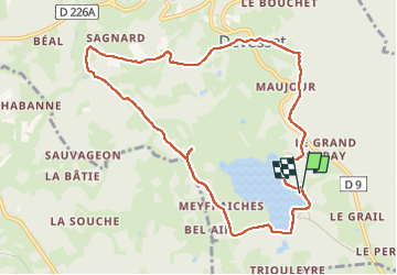
lac de Devesset Tour J3 HL

pascalmilpas
User

Length
10.4 km

Max alt
1174 m

Uphill gradient
209 m
Km-Effort
13.2 km

Min alt
1044 m

Downhill gradient
211 m
Boucle
Yes
Creation date :
2024-05-30 07:33:06.603
Updated on :
2024-05-30 10:47:30.579
3h10
Difficulty : Difficult

FREE GPS app for hiking
 SityTrail
IGN / Geographical institutes
SityTrail Plus
The world is yours!
About
Trail Walking of 10.4 km to be discovered at Auvergne-Rhône-Alpes, Ardèche, Devesset. This trail is proposed by pascalmilpas.
Description
Boucle au départ de la Base Loisirs
10 kms très faciles et larges chemins arborés avec de magnifiques ruisseaux et des arbres remarquables
Positioning
Country:
France
Region :
Auvergne-Rhône-Alpes
Department/Province :
Ardèche
Municipality :
Devesset
Location:
Unknown
Start:(Dec)
Start:(UTM)
609898 ; 4989651 (31T) N.
Comments