


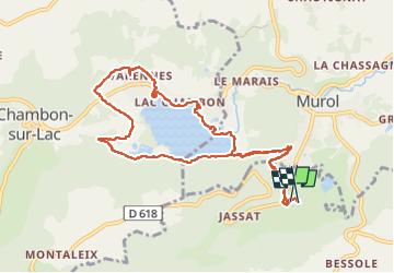
Autour du Lac de Chambon depuis le camping La Ribeyrie

Jean-marc77
User

Length
10.7 km

Max alt
923 m

Uphill gradient
249 m
Km-Effort
14 km

Min alt
850 m

Downhill gradient
251 m
Boucle
Yes
Creation date :
2024-05-30 08:38:20.061
Updated on :
2024-05-30 11:21:26.387
2h25
Difficulty : Easy

FREE GPS app for hiking
 SityTrail
IGN / Geographical institutes
SityTrail Plus
The world is yours!
About
Trail Walking of 10.7 km to be discovered at Auvergne-Rhône-Alpes, Puy-de-Dôme, Saint-Victor-la-Rivière. This trail is proposed by Jean-marc77.
Positioning
Country:
France
Region :
Auvergne-Rhône-Alpes
Department/Province :
Puy-de-Dôme
Municipality :
Saint-Victor-la-Rivière
Location:
Unknown
Start:(Dec)
Start:(UTM)
495186 ; 5045471 (31T) N.
Comments