


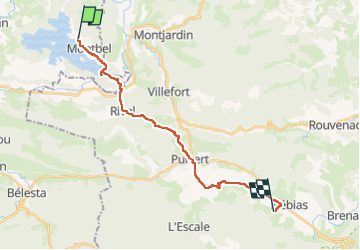
Carcassonne Quillan etap4

taguette
User

Length
20 km

Max alt
581 m

Uphill gradient
368 m
Km-Effort
24 km

Min alt
386 m

Downhill gradient
199 m
Boucle
No
Creation date :
2024-05-30 05:52:46.178
Updated on :
2024-05-30 13:31:25.741
4h25
Difficulty : Very difficult

FREE GPS app for hiking
 SityTrail
IGN / Geographical institutes
SityTrail Plus
The world is yours!
About
Trail Walking of 20 km to be discovered at Occitania, Ariège, Montbel. This trail is proposed by taguette.
Positioning
Country:
France
Region :
Occitania
Department/Province :
Ariège
Municipality :
Montbel
Location:
Unknown
Start:(Dec)
Start:(UTM)
415998 ; 4759179 (31T) N.
Comments