Trail Walking Château-d'Oex - Rocher du Midi - Photo
 Bachmann
Bachmann

User

© OpenStreetMap contributors
Length
Length
10.4 km
Max alt
Max alt
2075 m
Uphill gradient
Uphill gradient
1074 m
Km-Effort
Km-Effort  
25 km
Min alt
Min alt
1146 m
Downhill gradient
Downhill gradient
1046 m
Boucle
Boucle
Yes
Creation date :
2014-12-10 00:00:00.0
Updated on :
2014-12-10 00:00:00.0

(0 Reviews)

Walking
Walking
--
Difficulty : Unknown

Scan this QR Code to open this trail in the SityTrail application

FREE GPS app for hiking

Logo SityTrail SityTrail

IGN / Geographical institutes

Download SityTrail from the App Store Download SityTrail from Google Play

Logo SityTrail SityTrail World

The world is yours!

Download SityTrail from the App Store Download SityTrail from Google Play Download SityTrail on Huawei AppGallery

About

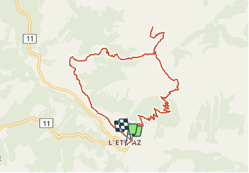
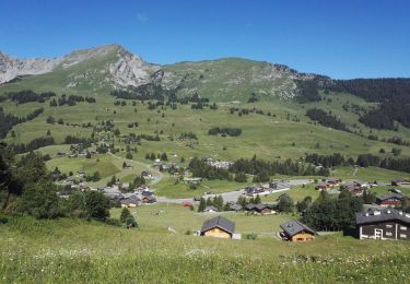
Trail Walking of 10.4 km to be discovered at Vaud, District de la Riviera-Pays-d’Enhaut, Château-d'Oex. This trail is proposed by Bachmann.

Description

Réalisée le 8 juillet 2010 par temps magnifique. Départ de l''Etivaz à 7h, retour à 13h, dans le sens horaire.
Le tronçon permettant de couper un bout de la route au départ est à éviter. Pas entretenu, ne sert à rien.
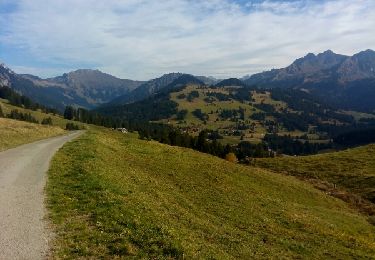
Par contre, le tronçon direct du col de Base au Plan de la Douve (point 2003) est beau. Pas entretenu, on le trouve, sauf la dernière partie non traçée: il suffit de monter au juger entre les rochers vers le chemin normal que l''on voit en haut sur sa gauche.
Il  y a une fontaine près du refuge (cabane pour l''entretien, propriété du canton de Vaud) indiqué au 1/3 de la descente du Plan de la Douve à l''Etivaz. Il y avait même des bières dans la fontaine, laissées intactes.

Elevation profile

Positioning

Country:
Switzerland
Region :
Vaud
Department/Province :
District de la Riviera-Pays-d’Enhaut
Municipality :
Château-d'Oex
Location:
Unknown
Start:(UTM)
357565 ; 5142781 (32T) N.

Trails nearby

Trail Walking Château-d'Oex - Circuit La Lécherette - col de Sonlomont - lac de l'Hongrin 18.08.2019 - Photo
Walking
duamerg

Walking

Medium
Château-d'Oex, Vaud, District de la Riviera-Pays-d’Enhaut, Switzerland
11.1 km | 16.4 km-effort
3h 25min
Yes
Trail Walking Château-d'Oex - Lac de l'Hongrin - Photo
Walking
chbolzli

Walking

Easy
Château-d'Oex, Vaud, District de la Riviera-Pays-d’Enhaut, Switzerland
16.7 km | 24 km-effort
3h 31min
Yes
Trail Touring skiing Ormont-Dessous - les mosses/pra croset - Photo
Touring skiing
baruc

Touring skiing

Easy
Ormont-Dessous, Vaud, District d'Aigle, Switzerland
10.1 km | 16 km-effort
4h 5min
No
Trail Walking Rougemont - La Pierreuse - Photo
Walking
GUIDE+

Walking

Very easy
Rougemont, Vaud, District de la Riviera-Pays-d’Enhaut, Switzerland
13.9 km | 23 km-effort
Unknown
No
Trail Walking Rougemont - w10_33_pierreuse - Photo
Walking
GUIDE+

Walking

Very easy
Rougemont, Vaud, District de la Riviera-Pays-d’Enhaut, Switzerland
10.1 km | 15.9 km-effort
3h 2min
No
Trail Walking Rougemont - La videmanette rougemont - Photo
Walking
chen.christophe

Walking

Very easy
Rougemont, Vaud, District de la Riviera-Pays-d’Enhaut, Switzerland
5.5 km | 10.7 km-effort
2h 34min
No
Trail Walking Ormont-Dessous - Lac Lioson - Photo
Walking
mallovon

Walking

Very easy
Ormont-Dessous, Vaud, District d'Aigle, Switzerland
7.8 km | 14.7 km-effort
4h 24min
Yes
Trail Walking Ormont-Dessous - Col des Mosses - Lac Lioson - Pra Cornet - Photo
Walking
duamerg

Walking

Medium
Ormont-Dessous, Vaud, District d'Aigle, Switzerland
9.6 km | 16 km-effort
3h 22min
Yes
Trail Winter sports Château-d'Oex - lecherette col sansolon  - Photo
Winter sports
gaille72

Winter sports

Difficult
Château-d'Oex, Vaud, District de la Riviera-Pays-d’Enhaut, Switzerland
8.7 km | 13.8 km-effort
4h 31min
Yes


Close
My subscriptions