


j5saint malo

LouisROGER
User GUIDE
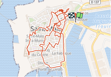

Length
5.2 km

Max alt
28 m

Uphill gradient
52 m
Km-Effort
5.8 km

Min alt
3 m

Downhill gradient
52 m
Boucle
Yes
Creation date :
2024-05-30 08:56:00.412
Updated on :
2024-05-30 14:32:51.746
5h35
Difficulty : Easy

FREE GPS app for hiking
 SityTrail
IGN / Geographical institutes
SityTrail Plus
The world is yours!
About
Trail Walking of 5.2 km to be discovered at Brittany, Ille-et-Vilaine, Saint-Malo. This trail is proposed by LouisROGER.
Positioning
Country:
France
Region :
Brittany
Department/Province :
Ille-et-Vilaine
Municipality :
Saint-Malo
Location:
Unknown
Start:(Dec)
Start:(UTM)
572036 ; 5389021 (30U) N.
Comments