


Ternand 11 km

daniellebou
User
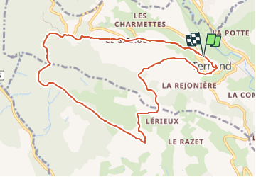

Length
10.8 km

Max alt
622 m

Uphill gradient
427 m
Km-Effort
16.4 km

Min alt
300 m

Downhill gradient
423 m
Boucle
Yes
Creation date :
2024-05-30 22:07:16.306
Updated on :
2024-05-30 22:08:03.459
3h44
Difficulty : Difficult

FREE GPS app for hiking
 SityTrail
IGN / Geographical institutes
SityTrail Plus
The world is yours!
About
Trail Walking of 10.8 km to be discovered at Auvergne-Rhône-Alpes, Rhône, Ternand. This trail is proposed by daniellebou.
Positioning
Country:
France
Region :
Auvergne-Rhône-Alpes
Department/Province :
Rhône
Municipality :
Ternand
Location:
Unknown
Start:(Dec)
Start:(UTM)
618349 ; 5089160 (31T) N.
Comments