


le mont caume de decatoutdoor

bernir
User
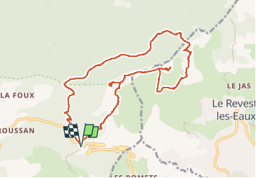

Length
12.1 km

Max alt
778 m

Uphill gradient
603 m
Km-Effort
20 km

Min alt
395 m

Downhill gradient
603 m
Boucle
Yes
Creation date :
2024-05-30 07:39:55.377
Updated on :
2024-05-31 06:18:45.042
8h07
Difficulty : Difficult

FREE GPS app for hiking
 SityTrail
IGN / Geographical institutes
SityTrail Plus
The world is yours!
About
Trail Walking of 12.1 km to be discovered at Provence-Alpes-Côte d'Azur, Var, Évenos. This trail is proposed by bernir.
Positioning
Country:
France
Region :
Provence-Alpes-Côte d'Azur
Department/Province :
Var
Municipality :
Évenos
Location:
Unknown
Start:(Dec)
Start:(UTM)
734754 ; 4783774 (31T) N.
Comments