


Nièvre boucle

BELLETGE
User
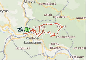

Length
8.5 km

Max alt
505 m

Uphill gradient
247 m
Km-Effort
11.8 km

Min alt
306 m

Downhill gradient
246 m
Boucle
Yes
Creation date :
2024-05-31 07:53:39.872
Updated on :
2024-05-31 10:35:17.653
2h15
Difficulty : Easy

FREE GPS app for hiking
 SityTrail
IGN / Geographical institutes
SityTrail Plus
The world is yours!
About
Trail Walking of 8.5 km to be discovered at Auvergne-Rhône-Alpes, Ardèche, Meyras. This trail is proposed by BELLETGE.
Positioning
Country:
France
Region :
Auvergne-Rhône-Alpes
Department/Province :
Ardèche
Municipality :
Meyras
Location:
Unknown
Start:(Dec)
Start:(UTM)
601730 ; 4946861 (31T) N.
Comments