


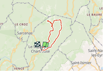
CHARTREUSE - brèche Arnaud accès

JMHRX2
User

Length
11.5 km

Max alt
1955 m

Uphill gradient
912 m
Km-Effort
24 km

Min alt
1003 m

Downhill gradient
912 m
Boucle
Yes
Creation date :
2024-05-29 08:21:21.017
Updated on :
2024-05-31 16:29:06.88
4h13
Difficulty : Very difficult

FREE GPS app for hiking
 SityTrail
IGN / Geographical institutes
SityTrail Plus
The world is yours!
About
Trail Walking of 11.5 km to be discovered at Auvergne-Rhône-Alpes, Isère, Le Sappey-en-Chartreuse. This trail is proposed by JMHRX2.
Positioning
Country:
France
Region :
Auvergne-Rhône-Alpes
Department/Province :
Isère
Municipality :
Le Sappey-en-Chartreuse
Location:
Unknown
Start:(Dec)
Start:(UTM)
718034 ; 5015411 (31T) N.
Comments