


le colombier

Auger91
User
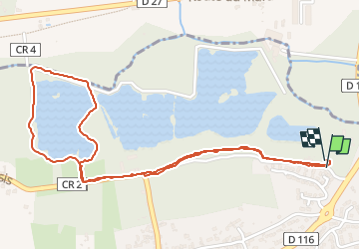

Length
2.8 km

Max alt
73 m

Uphill gradient
31 m
Km-Effort
3.2 km

Min alt
52 m

Downhill gradient
30 m
Boucle
Yes
Creation date :
2024-06-01 13:30:02.208
Updated on :
2024-06-01 14:28:54.897
50m
Difficulty : Easy

FREE GPS app for hiking
 SityTrail
IGN / Geographical institutes
SityTrail Plus
The world is yours!
About
Trail Walking of 2.8 km to be discovered at Ile-de-France, Essonne, Breuillet. This trail is proposed by Auger91.
Description
etang
Positioning
Country:
France
Region :
Ile-de-France
Department/Province :
Essonne
Municipality :
Breuillet
Location:
Unknown
Start:(Dec)
Start:(UTM)
438976 ; 5380799 (31U) N.
Comments