


la Fajolle

Mascart
User
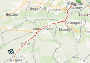

Length
10.4 km

Max alt
1088 m

Uphill gradient
521 m
Km-Effort
16.1 km

Min alt
708 m

Downhill gradient
149 m
Boucle
No
Creation date :
2024-06-01 05:22:10.394
Updated on :
2024-06-01 17:01:56.328
2h30
Difficulty : Medium

FREE GPS app for hiking
 SityTrail
IGN / Geographical institutes
SityTrail Plus
The world is yours!
About
Trail Walking of 10.4 km to be discovered at Occitania, Aude, Belfort-sur-Rebenty. This trail is proposed by Mascart.
Description
transhumance le long du Rebenty
Positioning
Country:
France
Region :
Occitania
Department/Province :
Aude
Municipality :
Belfort-sur-Rebenty
Location:
Unknown
Start:(Dec)
Start:(UTM)
422164 ; 4741849 (31T) N.
Comments