


Alsace juin 2024 12km

raymondvanroosbroeck
User
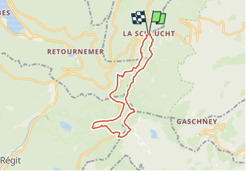

Length
12.3 km

Max alt
1352 m

Uphill gradient
459 m
Km-Effort
18.5 km

Min alt
1138 m

Downhill gradient
460 m
Boucle
Yes
Creation date :
2024-06-02 08:41:14.459
Updated on :
2024-06-02 08:59:18.57
4h11
Difficulty : Difficult

FREE GPS app for hiking
 SityTrail
IGN / Geographical institutes
SityTrail Plus
The world is yours!
About
Trail Walking of 12.3 km to be discovered at Grand Est, Vosges, Le Valtin. This trail is proposed by raymondvanroosbroeck.
Positioning
Country:
France
Region :
Grand Est
Department/Province :
Vosges
Municipality :
Le Valtin
Location:
Unknown
Start:(Dec)
Start:(UTM)
352695 ; 5325275 (32U) N.
Comments