


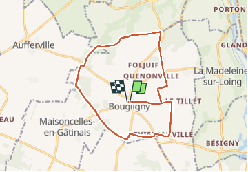
rando gourmande a Bougligny

Isidore Hernandez 2
User

Length
16.3 km

Max alt
123 m

Uphill gradient
86 m
Km-Effort
17.4 km

Min alt
104 m

Downhill gradient
86 m
Boucle
Yes
Creation date :
2024-06-02 07:05:42.425
Updated on :
2024-06-02 12:23:26.496
5h17
Difficulty : Easy

FREE GPS app for hiking
 SityTrail
IGN / Geographical institutes
SityTrail Plus
The world is yours!
About
Trail Walking of 16.3 km to be discovered at Ile-de-France, Seine-et-Marne, Bougligny. This trail is proposed by Isidore Hernandez 2.
Positioning
Country:
France
Region :
Ile-de-France
Department/Province :
Seine-et-Marne
Municipality :
Bougligny
Location:
Unknown
Start:(Dec)
Start:(UTM)
474590 ; 5338072 (31U) N.
Comments