


six fours

sacadostcv
User
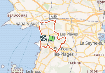

Length
13.2 km

Max alt
180 m

Uphill gradient
297 m
Km-Effort
17.2 km

Min alt
-1 m

Downhill gradient
297 m
Boucle
Yes
Creation date :
2024-06-02 07:18:40.189
Updated on :
2024-06-02 12:53:23.0
3h36
Difficulty : Difficult

FREE GPS app for hiking
 SityTrail
IGN / Geographical institutes
SityTrail Plus
The world is yours!
About
Trail Walking of 13.2 km to be discovered at Provence-Alpes-Côte d'Azur, Var, Six-Fours-les-Plages. This trail is proposed by sacadostcv.
Positioning
Country:
France
Region :
Provence-Alpes-Côte d'Azur
Department/Province :
Var
Municipality :
Six-Fours-les-Plages
Location:
Unknown
Start:(Dec)
Start:(UTM)
729532 ; 4775679 (31T) N.
Comments