


2_6_24

baudon
User
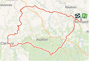

Length
208 km

Max alt
462 m

Uphill gradient
2709 m
Km-Effort
244 km

Min alt
108 m

Downhill gradient
2707 m
Boucle
Yes
Creation date :
2024-06-02 05:05:09.952
Updated on :
2024-06-02 20:09:40.119
14h57
Difficulty : Very difficult

FREE GPS app for hiking
 SityTrail
IGN / Geographical institutes
SityTrail Plus
The world is yours!
About
Trail Road bike of 208 km to be discovered at Bourgogne-Franche-Comté, Côte-d'Or, Montbard. This trail is proposed by baudon.
Positioning
Country:
France
Region :
Bourgogne-Franche-Comté
Department/Province :
Côte-d'Or
Municipality :
Montbard
Location:
Unknown
Start:(Dec)
Start:(UTM)
600830 ; 5275532 (31T) N.
Comments