


Montagne de Chanteduc (Eourres 05)

Clo0413
User
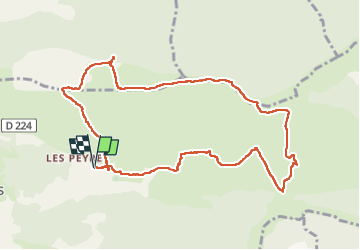

Length
11 km

Max alt
1548 m

Uphill gradient
589 m
Km-Effort
18.8 km

Min alt
969 m

Downhill gradient
588 m
Boucle
Yes
Creation date :
2024-05-26 07:29:17.992
Updated on :
2024-06-04 12:26:33.667
3h24
Difficulty : Medium

FREE GPS app for hiking
 SityTrail
IGN / Geographical institutes
SityTrail Plus
The world is yours!
About
Trail Walking of 11 km to be discovered at Provence-Alpes-Côte d'Azur, Hautes-Alpes, Éourres. This trail is proposed by Clo0413.
Positioning
Country:
France
Region :
Provence-Alpes-Côte d'Azur
Department/Province :
Hautes-Alpes
Municipality :
Éourres
Location:
Unknown
Start:(Dec)
Start:(UTM)
717216 ; 4899401 (31T) N.
Comments