


onnaing

José Mafrici 2
User
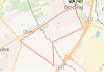

Length
8 km

Max alt
48 m

Uphill gradient
38 m
Km-Effort
8.5 km

Min alt
26 m

Downhill gradient
38 m
Boucle
Yes
Creation date :
2024-06-03 16:17:27.675
Updated on :
2024-06-03 17:12:03.421
54m
Difficulty : Very easy

FREE GPS app for hiking
 SityTrail
IGN / Geographical institutes
SityTrail Plus
The world is yours!
About
Trail Running of 8 km to be discovered at Hauts-de-France, Nord, Onnaing. This trail is proposed by José Mafrici 2.
Positioning
Country:
France
Region :
Hauts-de-France
Department/Province :
Nord
Municipality :
Onnaing
Location:
Unknown
Start:(Dec)
Start:(UTM)
542825 ; 5581895 (31U) N.
Comments