


Le rouret 06

papajp
User
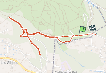

Length
3.2 km

Max alt
402 m

Uphill gradient
72 m
Km-Effort
4.1 km

Min alt
351 m

Downhill gradient
73 m
Boucle
No
Creation date :
2024-06-05 13:29:14.0
Updated on :
2024-06-05 14:29:05.674

FREE GPS app for hiking
 SityTrail
IGN / Geographical institutes
SityTrail Plus
The world is yours!
About
Trail of 3.2 km to be discovered at Provence-Alpes-Côte d'Azur, Maritime Alps, Châteauneuf-Grasse. This trail is proposed by papajp.
Positioning
Country:
France
Region :
Provence-Alpes-Côte d'Azur
Department/Province :
Maritime Alps
Municipality :
Châteauneuf-Grasse
Location:
Unknown
Start:(Dec)
Start:(UTM)
338526 ; 4838022 (32T) N.
Comments