


Xxxxxxxx

rando30129
User
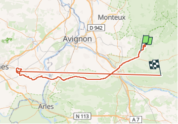

Length
159 km

Max alt
722 m

Uphill gradient
2561 m
Km-Effort
192 km

Min alt
0 m

Downhill gradient
2091 m
Boucle
No
Creation date :
2024-05-30 07:33:32.0
Updated on :
2024-06-06 07:56:10.629
11h25
Difficulty : Very difficult

FREE GPS app for hiking
 SityTrail
IGN / Geographical institutes
SityTrail Plus
The world is yours!
About
Trail Walking of 159 km to be discovered at Provence-Alpes-Côte d'Azur, Vaucluse, Cabrières-d'Avignon. This trail is proposed by rando30129.
Positioning
Country:
France
Region :
Provence-Alpes-Côte d'Azur
Department/Province :
Vaucluse
Municipality :
Cabrières-d'Avignon
Location:
Unknown
Start:(Dec)
Start:(UTM)
673152 ; 4862851 (31T) N.
Comments