


Laguiole 24 juan/fifi/zot

zot
User
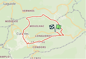

Length
17 km

Max alt
1336 m

Uphill gradient
508 m
Km-Effort
24 km

Min alt
925 m

Downhill gradient
506 m
Boucle
Yes
Creation date :
2024-06-06 07:30:50.0
Updated on :
2024-06-06 14:06:32.064
4h22
Difficulty : Medium

FREE GPS app for hiking
 SityTrail
IGN / Geographical institutes
SityTrail Plus
The world is yours!
About
Trail Walking of 17 km to be discovered at Occitania, Aveyron, Curières. This trail is proposed by zot.
Positioning
Country:
France
Region :
Occitania
Department/Province :
Aveyron
Municipality :
Curières
Location:
Unknown
Start:(Dec)
Start:(UTM)
493096 ; 4944553 (31T) N.
Comments