


chemin cathare roquefixade etap5

taguette
User
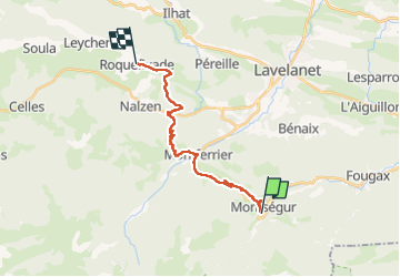

Length
17.9 km

Max alt
1058 m

Uphill gradient
633 m
Km-Effort
27 km

Min alt
584 m

Downhill gradient
765 m
Boucle
No
Creation date :
2024-06-06 06:48:03.151
Updated on :
2024-06-06 15:49:39.605
5h45
Difficulty : Very difficult

FREE GPS app for hiking
 SityTrail
IGN / Geographical institutes
SityTrail Plus
The world is yours!
About
Trail Walking of 17.9 km to be discovered at Occitania, Ariège, Montségur. This trail is proposed by taguette.
Positioning
Country:
France
Region :
Occitania
Department/Province :
Ariège
Municipality :
Montségur
Location:
Unknown
Start:(Dec)
Start:(UTM)
404658 ; 4746784 (31T) N.
Comments