


Trace Pla d Ailhet G4 Guy

mitch1952
User
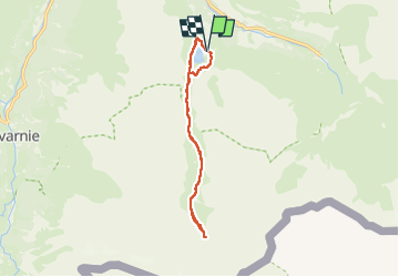

Length
12.5 km

Max alt
1861 m

Uphill gradient
269 m
Km-Effort
16.1 km

Min alt
1658 m

Downhill gradient
263 m
Boucle
Yes
Creation date :
2024-06-07 07:42:45.0
Updated on :
2024-06-07 15:36:36.067

FREE GPS app for hiking
 SityTrail
IGN / Geographical institutes
SityTrail Plus
The world is yours!
About
Trail of 12.5 km to be discovered at Occitania, Hautespyrenees, Gavarnie-Gèdre. This trail is proposed by mitch1952.
Positioning
Country:
France
Region :
Occitania
Department/Province :
Hautespyrenees
Municipality :
Gavarnie-Gèdre
Location:
Gèdre
Start:(Dec)
Start:(UTM)
258754 ; 4737421 (31T) N.
Comments