


entrevau

lboubis
User
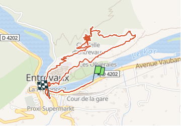

Length
3.5 km

Max alt
633 m

Uphill gradient
169 m
Km-Effort
5.7 km

Min alt
467 m

Downhill gradient
150 m
Boucle
No
Creation date :
2024-06-08 08:06:46.316
Updated on :
2024-06-08 09:52:33.325
1h45
Difficulty : Easy

FREE GPS app for hiking
 SityTrail
IGN / Geographical institutes
SityTrail Plus
The world is yours!
About
Trail Walking of 3.5 km to be discovered at Provence-Alpes-Côte d'Azur, Alpes-de-Haute-Provence, Entrevaux. This trail is proposed by lboubis.
Positioning
Country:
France
Region :
Provence-Alpes-Côte d'Azur
Department/Province :
Alpes-de-Haute-Provence
Municipality :
Entrevaux
Location:
Unknown
Start:(Dec)
Start:(UTM)
324588 ; 4868617 (32T) N.
Comments