


Sortie 150 ans du CAF enregistrement

psesjs
User
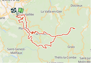

Length
50 km

Max alt
1422 m

Uphill gradient
1335 m
Km-Effort
67 km

Min alt
606 m

Downhill gradient
1335 m
Boucle
Yes
Creation date :
2024-06-08 05:59:25.496
Updated on :
2024-06-08 13:33:00.515
5h32
Difficulty : Difficult

FREE GPS app for hiking
 SityTrail
IGN / Geographical institutes
SityTrail Plus
The world is yours!
About
Trail Mountain bike of 50 km to be discovered at Auvergne-Rhône-Alpes, Loire, Saint-Étienne. This trail is proposed by psesjs.
Positioning
Country:
France
Region :
Auvergne-Rhône-Alpes
Department/Province :
Loire
Municipality :
Saint-Étienne
Location:
Unknown
Start:(Dec)
Start:(UTM)
611387 ; 5029195 (31T) N.
Comments